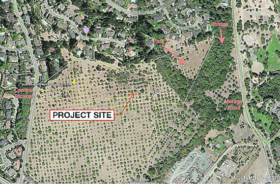
 | | | The project site Image provided
| | | | | | When the Moraga Planning Commission agreed in mid-December to the creation of a 2.5-acre nature area across from the Moraga Commons Park, it also recommended that this new park be accessed only through Camino Ricardo, or from the future development that will occur one day to the south of the property. The idea of crossing Moraga Road to link the two parks was not appealing to the commissioners. But on Jan. 6 town staff came to the commission to make the case for a connection to Moraga Road.
 Town Manager Jill Keimach described the vision of an integrated pedestrian network of trails and parks in Moraga and beyond. The commission finally approved, with conditions, an access from the new park across Laguna Creek (that borders the park along Moraga Road) to regional trails; the point of crossing Moraga Road at the existing traffic light or other location will be determined as part of the Livable Moraga Road plan.
The 5-acre nature area will be dedicated to the town by Summerhill Development as scheduled in its plan to develop a more than 12-acre parcel off Camino Ricardo and reaching Moraga Road to the east. At a previous meeting the Planning Commission recommended the elimination of a pedestrian bridge that would cross Laguna Creek and facilitate access from Moraga Road. The commissioners' concern was that people would leave their cars near the skate park and cross the busy arterial in an unsafe or traffic-disrupting manner. But town staff had a different vision regarding that connection.
"This community had seven years to look at the vision of the Moraga Center Specific Plan that included three pedestrian bridges," said Keimach. "(The bridge would) connect (the new park) to the Lafayette-Moraga Trail, that itself links to regional parks in the area. (We want to) create a walking community." She added that removing the bridge would create a public safety issue, making it more secluded and less accessible to law enforcement and medical services. "Look at the big picture," she urged. "You are making a big decision tonight."
Staff also discussed the financial aspects of the bridge construction. "It would be more expensive for the town to build one bridge in the future than to have the developer build two bridges at the same time," said Planning Director Shawna Brekke-Read; the second bridge she referenced would serve as a connection within the park.
The commissioners started shifting their positions regarding the bridge, understanding the need for pedestrian connectivity but struggling with supporting the construction of a new crosswalk on Moraga Road. "We are going to become downtown Lafayette with all the crossings that we have," said Planning Commissioner Stacia Levenfeld. "(This would have a) significant impact on the scenic corridor and semi-rural feel." Other commissioners, concerned with the impact on the riparian corridor and the protection of pedestrian safety, proposed to build the bridge as far south as possible leading not to Moraga Road but to a trail that would reach the protected intersection of Saint Mary's Road and Moraga Road.
"We want to have access to this parcel from the regional trails, with a focus on the safety of pedestrian access rather than a crosswalk," summarized Levenfeld.
The location of the new Laguna Creek bridge will be as far south as possible to minimize environmental impacts. Prior to opening the bridge for public use, a safe pedestrian crossing will be established to maximize pedestrian safety and connectivity from the Laguna Creek bridge to regional trails. Even though a new crosswalk on Moraga Road was not ruled out the idea did not gain much momentum with the commission, which will approve the final location of the crossing.
|
