 | | | Hillside ridgeline 1: Building height calculation on a slope Images provided | | | | | | Planning commissioners were reluctant to support a new proposed rule limiting development in high-risk areas to one dwelling unit per 20 acres, even when hazards such as landslides have been mitigated. This change is a cornerstone for those in town who seek reinforcement of the protection of Moraga open space. But a majority of the commissioners felt that it would lead to property owners never improving high-risk areas. The proposed changes were nonetheless forwarded to the Moraga Town Council for final review, with a comment regarding the commissioners' concerns.
 The town has been working on amending its hillside and ridgeline regulations since 2014. Planning Director Ellen Clark explains that the purpose of this work is to increase certainty for development, clarify the rules and make them consistent across the different planning documents. She adds that this is in keeping with the community's wish to protect the town's character.
 The regulations that are now in the final phase of approval have been developed following a comprehensive outreach and study process, including several community meetings and work by a steering committee, as well as consultative boards and commissions.
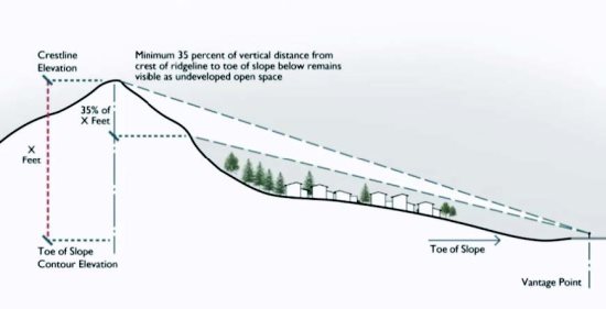
 Some of the proposed new rules were supported by the commissioners. For example, making sure that new developments on hillsides leave at least 35 percent of that hill untouched, as seen from scenic corridors. A first version of the text had proposed that any place along the scenic corridors be used to check the 35 percent undeveloped rule, but instead, staff proposed that certain specific vantage points be defined around town from which the views will need to be protected. Clark explained that this approach made it more predictable and fair to developers.
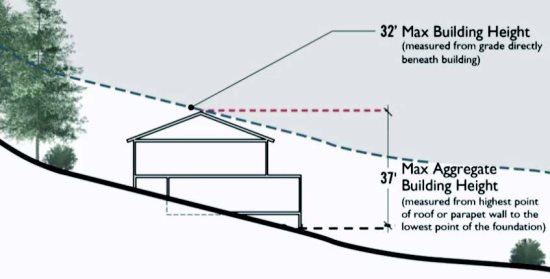
 The commissioners also discussed the maximum height permitted on a hillside lot. Currently the maximum height for a building is 35 feet measured from the top of the highest part of the building to the grade below that part, and a 45-foot aggregate, measured from the highest point to the lowest point of the foundation. The new maximums would be 32 feet and 37 feet for the aggregate.
 The commissioners were concerned, however, with a rule that would limit in perpetuity development in high-risk areas to one home per 20 acres, even if the developer remediates the site to a non-hazardous status. Until now, if a developer amended the site, it would become eligible for a one home per 5 acres rule. Staff indicated that this change would be compliant with the Moraga Open Space Ordinance that was approved by voters. Commissioner Steve Woehleke said that this would be non-compliant with the General Plan and could not be supported by the commission. Chair Christine Kuckuk agreed and was followed by most of the other commissioners present.
 Several property owners and developers spoke in opposition of the new text. David Bruzzone, whose family owns most of the open space undeveloped in Moraga, said that the process was destructive to the future of the community, that it would create a more convoluted process for developers, and that the only certainty was that the town would have to face a lawsuit. He added that these changes would preclude development in the downtown as well.
 Michael Carradine, who also owns a lot in a MOSO area, asked the town to stop the process. He said that in 2008 the residents rejected at the November ballot strengthening the open space development regulations, and that staff or elected officials had no mandate to change what the voters did not want to touch.
 Other residents expressed their support of the change, including Suzanne Jones for the Protect Lamorinda Open Space and former mayor Lynda Deschambault.
 New commissioner Karl Davis wanted to study the proposed regulations de novo, but his colleagues did not support his request. The commissioners approved forwarding the proposed amendments to the town council, adding that a majority did not support changing development density rules in high-risk areas.


|

