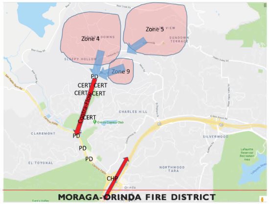
 | | | Evacuation areas and traffic flow guide for north Orinda exercise. Image MOFD | | | | | | With information gleaned from the Moraga emergency evacuation exercise in December, and prepared to expand the drill into a larger area and onto a major freeway, the Moraga-Orinda Fire District, in partnership with the Orinda and Moraga police departments, the California Highway Patrol and the Lamorinda Community Emergency Response Team, will conduct a second Lamorinda wildfire evacuation exercise in north Orinda on Saturday, Jan. 26.
 At 7 a.m. that day a Community Warning System alert will be sounded to participating residents of the Sleepy Hollow, Dalewood-Orinda Downs and Upper Miner Road neighborhoods. Evacuees will travel from their homes to the intersection of Miner Road and Lombardy Lane. From there, law enforcement and CERT volunteers will direct traffic along Miner, which will be closed to eastbound traffic and all lanes converted to westbound only, to Camino Pablo. Evacuees will drive southbound on Camino Pablo to the Highway 24 on ramps. All roads will reopen and revert to normal driving patterns by 8 a.m.
The Moraga Country Club area was chosen as the site for the December evacuation because of its relatively small size, the cooperation from the MCC homeowners association and because the country club has only one way in and one way out. The drill included 360 residents, 120 cars and 74 CERT members - the largest turnout of the group ever, according to Fire Chief Dave Winnacker. The exercise continued along Moraga Way to the Glorietta Boulevard intersection.
The north Orinda drill will encompass three major zones, with 1,400 homes having been notified of the evacuation exercise.
As traffic will be routed to Highway 24, the drill will provide information on what the on ramps would look like during an evacuation. "That is the critical juncture," Winnacker said. "We will work with our partners at the CHP to facilitate the rapid exit from the district through the use of those on ramps."
Once north Orinda evacuees arrive at Camino Pablo during the Jan. 26 drill, those in the right lane will be directed to Highway 24 westbound with drivers in the left lane directed eastbound. "The idea is to get folks onto the freeway and out of the district," Winnacker said. "We're not worried about where you're trying to get. We're only concerned about getting you out of the district."
Drivers should also note that, according to Orinda Police Chief Mark Nagel, when police officers are directing traffic, drivers must follow their instructions, even if the instructions conflict with traffic lights or signs.
Those who have yet to sign up for the Jan. 26 evacuation exercise should go to https://sites.google.com/
view/orinda-evacuation-
exercise/home. Winnacker urges all district residents to register for alerts from the Contra Costa County Community Warning System at cwsalerts.com.
Wildfire evacuations are complex procedures, with law enforcement directing residents out of the burning area as fire personnel and apparatus are storming in, and the data collected in these drills will aid future multiagency efforts. Observers will be posted along the evacuation route to record time, the number of vehicles, and identify areas subject to congestion. Participants will receive an email poll later that day to collect their feedback on the exercise.
Lafayette plans to conduct its own evacuation drill in March, according to Ben Alldritt, chief of police. "Initial thoughts are the Springhill or Happy Valley areas," he said. The chief said he will sit down with Dennis Rein, Lamorinda emergency preparedness coordinator, and lay out the parameters based on what was learned in the Moraga and Orinda drills. |
