| ||||||
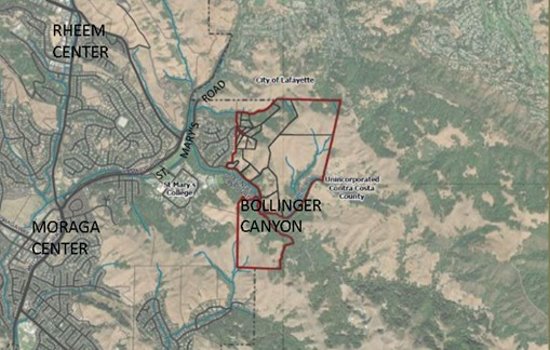
According to the staff report by Moraga Planning Director Afshan Hamid and Consultant Barry Miller, "If approved, the two resolutions would: 1) Adopt CEQA findings and a Statement of Overriding Considerations for the Bollinger Canyon General Plan Amendments and Rezoning, based on the previously certified Comprehensive Advanced Planning Initiative EIR. 2) Adopt text amendments to the Moraga General Plan relating to the Bollinger Canyon Study Area and definitions of land use categories, and amend the Moraga General Plan Map to replace the `Study' designation for Bollinger Canyon with a combination of Non-MOSO Open Space, Rural Residential, and 1 Dwelling Unit/Acre designations. The ordinance implements the associated General Plan Amendments by creating a Rural Residential Zone, rescinding the Study Zone, and amending the zoning map for the Bollinger Canyon Study Area."
Back in 1983, Moraga, Lafayette and Contra Costa County participated in a 3,400-acre multi-jurisdictional land use study that included the Bollinger Canyon Special Study Area. It was discovered that the area contained a "fragile ecosystem where very low-density residential use is to be a privilege and more intensive use would be inappropriate."
In 2019, and subsequent years, the council considered the rezoning of the Study Area as a one of its goals and priorities. A "White Paper" was prepared by staff in January 2022, which presented options for the Study Area. Its purpose was to describe physical context, planning and zoning history, identify potentially applicable zoning districts, provide general zoning principles and define three "parcel groups" while presenting zoning options.
The 20 parcels were grouped into three categories based on their common characteristics. Parcel Group 1 included developed residential properties at the east end of Joseph Drive and a single developed property on Bollinger Canyon Road. The entire area includes nine parcels ranging in size from 0.97 to 3.78 acres totaling 17.3 acres. Parcel Group 2 included four parcels with a combined 139 acres that have recently become part of the Harvey Ranch John Muir Land Trust. Parcel Group 3 included seven parcels totaling 270 acres. Two of the eastern-most parcels (186.3 acres) had once been proposed as a 129-lot subdivision (Bollinger Valley Project).
The "White Paper" was presented during a virtual meeting that same month to more than 40 attending residents in order to collect input which was incorporated with feedback from a Feb. 9 Town Council meeting. Staff used the information to develop a General Plan and zoning proposal for the Study Area which was presented on May 24, 2022 to the Planning Commission.
For Parcel Group 1, a General Plan and zoning designation of "Residential - 1 Dwelling Unit per Acre" (1DUA) was proposed. According to the staff report, "The median lot size in the parcel group is 1.77 acres, and the prevailing character is single-family residential. All but one of the parcels is already developed with a single-family residence. Moreover, Parcel Group 1 is functionally part of the Bluffs neighborhood, which has a 1 DUA designation.
"A General Plan and zoning designation of 'Non-MOSO Open Space' was proposed for Parcel Group 2. All four of these parcels are in single ownership and have been acquired by the John Muir Land Trust. The proposed designation is consistent with the intent to retain these properties as open space for conservation and recreation."
Lastly, for Parcel Group 3, a new General Plan designation and zoning district was proposed. "This designation - Rural Residential - has a density of one dwelling unit per 5 acres and is intended to provide a transition between the Bluffs neighborhood to the west and the open space and agricultural areas to the north and east. Similar density limits apply to the north in Lafayette and to the east in Contra Costa County. Staff developed draft General Plan and Zoning text for this new district, including development standards and permitted uses."
Public comment from property owners in the Valley Hill and Bluffs area expressed concerns about traffic and road conditions, safety (wildfire, landslides, etc.), evacuation capacity and neighborhood character/aesthetics. The largest landowner (186 acres) requested density higher than 1 unit per 5 acres.
After taking everything into consideration, the Town Council certified the FEIR (Final Environmental Impact Report) on Jan. 25, 2023. This action also included a Mitigation Monitoring and Reporting Program (MMRP) for the entire project.
The Planning Commission's April 11 feedback to the council expressed general support for staff's updated proposal after questions/comments relating to expected VMT (Vehicle Miles Traveled) with regards to electric vehicles, opportunities for density transfer, expected access points for future development, process for planned development, opportunity for owner-initiated General Plan Amendment requests, and wildfire risk assessment requirements were discussed.
The Town Council voted 4-1 (Vice Mayor Teresa Onoda voted against) to approve the two resolutions and waive the first reading and introduce by Title only the ordinance amending the Moraga Municipal Code as it relates to the Bollinger Canyon Study Area.
Reach the reporter at:
