Lamorinda CERT’s drone presentation highlights usage within law enforcement and wildfire situations
Drones have become a popular piece of surveillance equipment, not only in today’s warfare to carry weapons, such as explosives, onto a battlefield or over civilian neighborhoods, but in law enforcement and for fighting fires as well.
Lamorinda CERT held a Nov. 10 Zoom meeting with a presentation by East Bay Regional Park District Police Officer John Cornell about drones in law enforcement, fire protection and response, military, and commercial use.
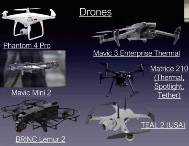
Cornell previously worked for the Lafayette Police Department as an Emergency Preparedness Coordinator and helped start the Contra Costa County Sheriff’s drone team. He also enhanced the capabilities of the Lamorinda Area Radio Interest Group and facilitated the installation of over 50 wildfire cameras throughout six counties. According to Cornell, almost every agency in law enforcement has drones. It’s an easy tool to use for everything from mapping, making 3D models of buildings, finding criminals on the run, or people that are lost. Firefighters also use drones that are tethered to their trucks. All in all, “it’s a safer alternative to send a drone into a building to assess the situation.”
The Contra Costa County Sheriff’s Office Drone Team was established in 2016, and has over 25 sworn and licensed pilots. Their current fleet of 30 drones see approximately 200 deployments per year. Currently CCCSO has at least one operator on duty 24/7, and that operator could be reporting from a far end of the county depending on where an emergency is located.
The drone of choice is DJI thanks to its superior camera quality, reliability, and price. Cornell noted that the Wingtra drone has vertical landing and takeoff capabilities, can perform high resolution mapping, is fully autonomous, and can stay aloft for one hour per 500 acres. “There are drones out there that will lift 100 pounds,” explained Cornell.
When the Moraga-Orinda Fire District conducted its Wildland Fire Training Burn on Painted Rock in 2023, a drone was used to map the controlled burn. Also, with the help of a Wildfire Camera System to detect fires on red flag days, a drone can be launched and flown over the fire saving on man hours by helping to determine the amount of man power that might be necessary.
The Federal Aviation Administration has adopted the term “If you fly, we can’t.” Flying recreational drones over or near wildfires could cause injury or death to firefighters and hamper the effectiveness of wildfire suppression operations. If recreational drones are detected over or near a wildfire, aerial firefighting aircraft may be grounded, causing wildfires to grow larger and unduly threaten lives, property, and natural and cultural resources. Individuals who interfere with wildfire suppression efforts may be subject to civil penalties and criminal prosecution.
The FAA reported that “in 2019, at least 20 documented instances of unauthorized drone flights over or near wildfires in eight states (Arizona, California, Colorado, Nevada, New Mexico, Utah, Washington, and Minnesota) have resulted in aerial firefighting operations being temporarily shut down nine times.”
Cornell summed it up best by saying, “Drones are a daily occurrence now.”
Copyright 2026, Lamorinda Weekly