| | Published September 6th, 2015
| Scout revitalizes map of America on Los Perales playground
| | | By Cecilia Murtagh |  | | Christophe Marinier with his map. Photo provided |
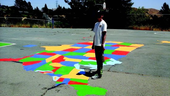
The cry went out, "Where is Rhode Island? Someone painted over Rhode Island!" The project director, Christophe Marinier, walked over with the green paint and replaced the missing state. National disaster averted! This happened as Marinier, an Eagle Scout candidate from troop 234, recently worked on his project to repair and repaint the large playground map of the United States at Los Perales Elementary School.
 When asked why he chose to spruce up the map he said that he had enjoyed playing around it when he was a student at LP and it had inspired his love of maps. He noticed that the map, which was originally done by the Moraga Rotary Club, had faded over the years and was in disrepair. He sought permission from the school principal, who suggested that the Scout include the basketball and four square courts.
 Marinier sought help at Home Depot where he talked to the experts to find out exactly what this job would entail. He found out it would take more than just paint. It would take money and many hours by many volunteers to complete. He estimated costs, and solicited funds from people who also wanted to preserve the map.
 Then he reached out for help. He organized a core group of Scouts: Haden, Christian and Tristan Prizeman, Siegfried Needham, Mason Gruebelle, Andy Babson and Sam Lee, who brought along his brother and grandfather. These stalwart Scouts were joined by Marinier's parents Philippe and Celia, his sisters Camille and Brigitte, and his grandfather Bob Murtagh. They in turn drafted Noel Wolfe and his family, Maura, Ellie and Will.
 As the big day approached Marinier gathered his supplies. He needed to procure paint, a gas blower, a power washer, sand, and asphalt. After the blower and broom crew finished, the entire surface needed to be power washed. Next the sand crew, followed by the asphalt crew, filled in the many large cracks that had appeared in the playground surface over the years. Then, the whole thing had to be primed. Finally, the cartographers, with their paints, could get to work on the map while another group worked on the four square courts, and still others painted the basketball courts. As it took shape Marinier knew that he had chosen his project well. It turned out better than he imagined.
 The LP students get to enjoy the map this year and Lamorinda Weekly readers can see the finished product on Google Earth.


|
| | | | | | | | | | | | |


