| | Published August 14th, 2024
| Lafayette City Council modifies connecting Lafayette plans
| | | By Elaine Borden Chandler |  | | Image courtesy City of Lafayette |
The Lafayette City Council has decided to proceed with the plans for Connecting Lafayette. Connecting Lafayette is a project that aims to improve the transportation around Stanley Middle School and Lafayette Elementary School. The main plan is to create a pedestrian and bicycle pathway that connects the schools, the downtown, and the Lafayette-Moraga pathway. However, due to community feedback, the council is investigating if they can modify the Topper Lane portion of the plans.
 The original plans were introduced at the City Council meeting on July 8, by Transportation Program Manager Patrick Golier, Nate Levine, a professional engineer, and Engineering Services Manager Matt Luttropp. The project has three sources of funding: the federal government's Transportation, Housing and Urban Development bill; the Metropolitan Transportation Commission's (MTC) One Bay Area Grant program; and local funding from Measure J and the Lamorinda Fee & Financing Authority (LFFA).
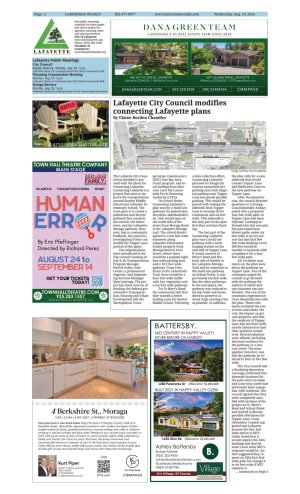
On School Street, Connecting Lafayette's plan was for a multi-use pathway for pedestrians, bicyclists, skateboarders, etc. that would span on the north side of the street from Moraga Road to the Lafayette-Moraga trail. The school district agreed to a ten foot wide easement along Lafayette Elementary School property from Moraga Road to First Street, where there would be a painted eight foot wide parking lane and a 10.5 foot wide pathway. From First Street to the Lamorinda Trail, there would be a four foot wide buffer with low vegetation and a ten foot wide pathway.
For St Mary's Road, the community said that they wanted a better loading zone for Stanley Middle School. Following a data collection effort, Connecting Lafayette planned to change the current unmarked dirt parking area with diagonal parking near Topper Lane into paved parallel parking. This would be paired with making the sidewalk from Topper Lane to Acampo Drive continuous and six feet wide. This sidewalk is the only part of the plan that does not have funding.
The last part of the Connecting Lafayette plan was a multi-use pathway with a landscaping section on the east side of Topper Lane. It would connect St Mary's Road and the back side of Stanley to the Lafayette-Moraga Trail and by extension to the multi-use pathway on School Street. It was previously ten feet wide like the other pathways. In the new plans, the pathway was reduced to six feet wide and meandered to preserve as many large existing trees as possible. In addition, the plan calls for a new sidewalk that would connect Topper Lane and Birdhaven Court to the new pathway on Topper Lane.
After the presentation, the council directed questions to Luttropp. Councilmember Anduri asked why a proposed four foot wide path on Topper Lane had been rejected. Luttropp informed him that not only has past experience shown paths under six feet wide to be too narrow but also that five foot wide landings every 200 feet would be needed to maintain ADA compliance for a four foot wide path.
All 14 citizen comments on the plan were about the pathway on Topper Lane. Two of the comments urged the council to go forward with the pathway for matters of safety and one comment was ambivalent. The rest of the comments expressed serious dissatisfaction with the plan. These comments included the loss of trees and shade, the cost, the impact on private property, and that the residents of Topper Lane had not been sufficiently informed or had their opinions considered. Several solutions were offered, including alternate locations for the pathway or a one-way street. The most popular, however, was that the pathway be reduced to four or five feet wide.
The City Council had a finalizing discussion. Luttropp confirmed that alternate locations for the path were unviable and a one-way street had previously been unpopular with residents. The council agreed that they were completely satisfied with sections of the project on St. Mary's Road and School Street and started to discuss possible alterations for Topper Lane. Councilmember Candell suggested that Lafayette present the four foot wide option to MTC. Golier noted that it would require the ADA landings and that he wasn't sure what MTC's response would be. Anduri suggested they request an ADA four foot wide path but change it to six feet wide if MTC requires it. Vice Mayor Kwok suggested that they request a four foot wide path, then five feet wide if that is rejected, and then return to six feet wide if necessary.
The council passed a motion that the Connecting Lafayette designs be approved but that the staff submit a request to change to an ADA four or five foot wide pathway to MTC. Another motion was then passed that when the Topper Lane pathway is constructed that the staff try to preserve and then plant as many trees as possible. |
| | | | | | | | | | | | |