
Lafayette-Moraga Regional Trail celebrates 50 years with upcoming interpretive panels
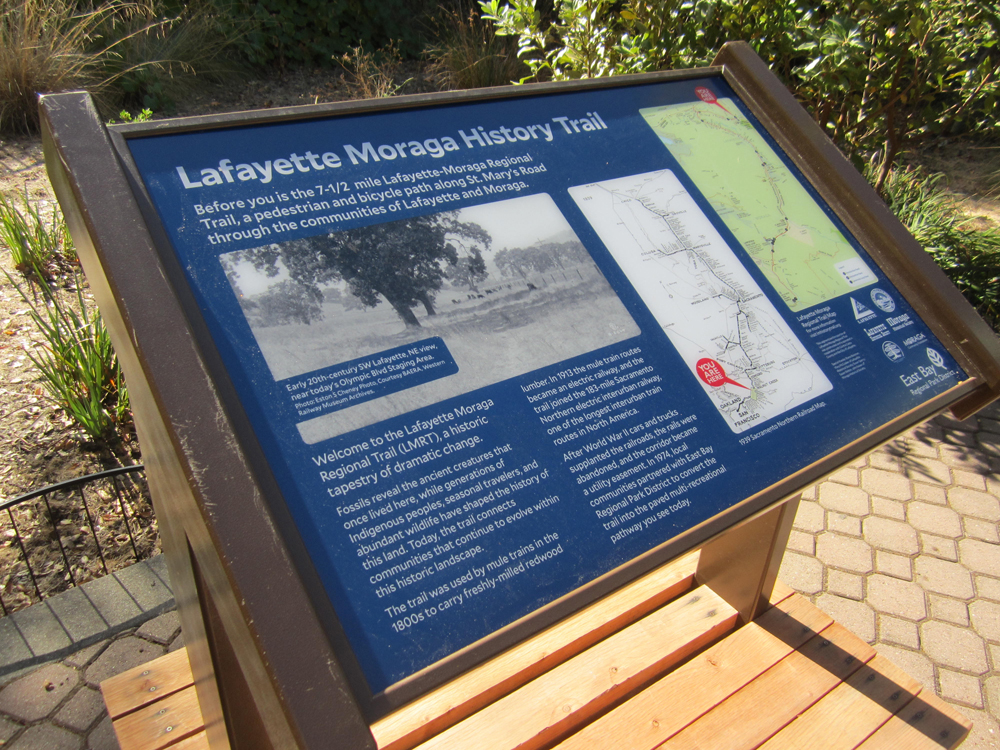
The East Bay Regional Park District celebrated the 50th anniversary of the Lafayette-Moraga Regional Trail with an Oct. 10 open house and exhibit preview of the new interpretive panels that will grace designated spots along the trail for pedestrians and cyclists to enjoy. The event was held at the Lafayette Community Center’s Jennifer Russell Building and gave the public an opportunity to examine the panels that are anticipated to be installed along the 7.65-mile trail by the end of 2026.
Shane Reisman, the project’s initiator and community coordinator, worked on history trails in other cities and began this current process in 2024. He stated, “The Lafayette-Moraga Trail is one of the most heavily used trails in the East Bay Regional Park District, yet I was surprised that there was so little along the trail to tell the stories of the communities it connects. I brought the idea forward and helped organize the talents, energy, and passions of the various stakeholders to turn it into something tangible.”
Reisman added, “The 50th anniversary provided a wonderful opportunity and a natural deadline, but the larger goal was always to create something lasting. We wanted to make local history accessible, engaging, and part of everyday life for generations of families and visitors.”
The Park District developed the panels in partnership with the Town of Moraga, City of Lafayette, Lafayette Historical Society, Moraga Historical Society, Moraga Community Foundation, and Community Foundation of Lafayette.
The panels cover the route of the Sacramento Northern Railway from Lafayette to Moraga. Each panel’s information was derived from local historical society input along with “of the era” photographs. The trail was originally used by mule trains in the 1800s to transport milled redwood lumber. In 1913, the routes became an electric railway that joined the 183-mile Sacramento Northern interurban railway – one of the longest in the United States. After WWII, the rails were abandoned as more people began to use cars, and the line became a utility easement. In 1976, local communities partnered with East Bay Regional Park District to create today’s current paved multi-recreational pathway.
There will be nine panels along the trail giving a brief history of each location with two more at the Russell Building. Beginning in Lafayette, Panel 1 (Reliez Station Road) described as the trail’s entrance, gives a short overview of the entire route’s history. Panel 2 (Topper Lane) explains the transit route that connected lumber mills of the Oakland Hills to shipping ports in Martinez in the mid-1800s. Also mentioned is Lafayette founder Elam Brown’s role. Panel 3 (Glenside Drive) discusses the 1939 trains that would take passengers right into San Francisco via the lower deck rails on the new Bay Bridge. Panel 4 (Lafayette Community Center) mentions the proposed “Shepherd Canyon Freeway” that would have bisected Moraga Valley and Burton Valley.
Coming into Moraga, Panel 5 (Rheem Boulevard and St. Mary’s Road) cites the prehistoric life that once called the area home. Panel 6 (Saint Mary’s College) reveals its 1927 move to Moraga along with its ties to the Navy during WWII. Panel 7 (Moraga Commons) provides a synopsis of the Town’s early ranching history beginning with Joaquin Moraga. Panel 8 (Moraga Country Club) tells of the 1912 purchase of 5,000 acres by James Irvine to develop his Moraga Company’s agribusiness of which the Bartlett pear was his largest crop. Lastly, Panel 9 (Valle Vista) was Moraga Company’s first subdivision in 1914, but by 1924, the East Bay Water Company (EMUD’s precursor) bought out the homeowners in order to create the Upper San Leandro Reservoir.
“The trail itself is a wonderful example of what community vision can accomplish,” said Reisman. “Fifty years ago, local residents helped transform an abandoned railroad corridor into a public treasure. Now, we’re building on that legacy by helping people discover the stories behind the places they pass every day.”
For more information visit: lmhistorytrail.org.
Copyright 2026, Lamorinda Weekly